The Florida Keys work as a day trip from Miami if you turn around at Islamorada or Marathon. Key West is about 160 road miles and roughly four hours each way, so it really needs an overnight. This plan lists every worthwhile stop on US-1 by mile marker, from John Pennekamp Coral Reef State Park at MM 102.5 to the Key deer of Big Pine Key at MM 30.5, so you can build the day around how far you actually want to drive.
Plan your visit
- Choose your turnaround point: Islamorada, Marathon or Big Pine Key.
- Leave Miami by 7 a.m. and fill the tank in Florida City.
- Snorkel or take the glass-bottom boat at Pennekamp in the morning.
- Eat lunch in Islamorada, then feed the tarpon at Robbie’s.
- Swim at Anne’s Beach or Sombrero Beach in the early afternoon.
- Walk the Old Seven Mile Bridge near sunset.
- Head north before dark and check traffic on the 18-Mile Stretch.
Pick your turnaround point before you leave
The biggest mistake South Florida residents make with the Florida Keys is treating them as one destination. The island chain runs more than 120 miles along a single, mostly two-lane highway with speed limits between 35 and 55 mph. Every mile you push south is a mile you drive back in the dark.
The official tourism council splits the keys of Florida into five regions: Key Largo, Islamorada, Marathon, Big Pine and the Lower Keys, and Key West. For a same-day trip from Miami-Dade, the realistic choice is between the first three. Pick yours with the table below, because it decides your departure time, your lunch stop and how tired you will be on the Turnpike at 9 p.m.
| Turnaround | Mile marker | Round trip from downtown Miami | Hours on the road (light traffic) | Who it suits |
|---|---|---|---|---|
| Key Largo | MM 106 to 91 | About 120 miles | 2.5 to 3 | Families, first snorkel trip, half day |
| Islamorada | MM 90 to 72 | About 160 to 190 miles | 3.5 to 4 | Most day-trippers, the best balance |
| Marathon and Seven Mile Bridge | MM 53 to 40 | About 220 to 230 miles | 5 to 5.5 | Full day, early start, bridge views |
| Bahia Honda and Big Pine | MM 37 to 30 | About 250 to 260 miles | 6 to 6.5 | Long summer days, beach-first trips |
| Key West | MM 0 | About 320 miles | 7.5 to 8+ | Overnight only |
Islamorada is the sweet spot for most people. You get the reef, a good lunch, a real beach and the tarpon at Robbie’s without spending half your day behind a camper on a two-lane bridge. Choose Marathon if the Seven Mile Bridge is the main reason you are going, and choose Bahia Honda only if you can leave by 6:30 a.m.
Drive times from Miami, Fort Lauderdale and Palm Beach
Everyone in South Florida reaches the Keys through the same funnel: Florida’s Turnpike Homestead Extension to its end in Florida City, then US-1 south. Broward and Palm Beach residents simply start further up that funnel, which shifts the whole schedule.
The times below assume a weekday morning with normal traffic and no stops. Add 30 to 60 minutes on Friday afternoons, holiday weekends and during lobster mini-season in July.
| Destination (mile marker) | From downtown Miami | From Fort Lauderdale | From West Palm Beach |
|---|---|---|---|
| Florida City, end of Turnpike (MM 126) | 35 mi / 45 min | 60 mi / 1 hr 5 min | 105 mi / 1 hr 45 min |
| Key Largo, Pennekamp (MM 102.5) | 60 mi / 1 hr 15 min | 85 mi / 1 hr 35 min | 130 mi / 2 hr 15 min |
| Islamorada, Robbie’s (MM 77.5) | 85 mi / 1 hr 45 min | 110 mi / 2 hr 5 min | 155 mi / 2 hr 45 min |
| Marathon, Turtle Hospital (MM 48.5) | 115 mi / 2 hr 30 min | 140 mi / 2 hr 50 min | 185 mi / 3 hr 30 min |
| Bahia Honda State Park (MM 37) | 125 mi / 2 hr 45 min | 150 mi / 3 hr 5 min | 195 mi / 3 hr 45 min |
| Key West, Mallory Square (MM 0) | 160 mi / 3 hr 45 min | 185 mi / 4 hr 5 min | 230 mi / 4 hr 45 min |
If you live in Palm Beach County, Key Largo or Islamorada is your practical limit for a single day. When the goal is simply clear water and a reef close to home, you may be better served by Peanut Island in Palm Beach for snorkeling, which has calm shallow water and no four-hour drive.
How the mile markers work
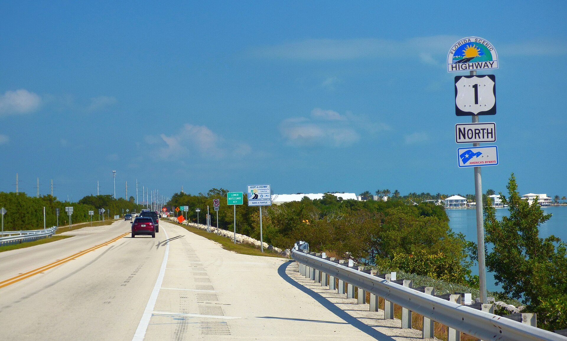
Every address and every set of directions in the Florida Keys uses mile markers, the small green signs along the shoulder of US-1. They count down from about MM 126 near Florida City to MM 0 at the corner of Whitehead and Fleming streets in Key West. A restaurant listed at “MM 82.5 bayside” is 82.5 miles from Key West, on the Florida Bay side of the road.
Two terms come up constantly:
- Oceanside means the Atlantic side, the side facing the reef. Driving south, it is on your left.
- Bayside means the Florida Bay or Gulf side. Driving south, it is on your right.
This matters more than it sounds. US-1 is often divided by a median, and in the Upper Keys you cannot always turn left across traffic. If a stop is oceanside and you are heading south, you turn left; on the way back north it becomes an easy right turn. Plan to hit oceanside stops on the drive home when the left turn looks tricky, and bayside stops on the drive down.
Decimal markers are standard, so MM 102.5 sits halfway between the MM 102 and MM 103 signs. Most mapping apps understand mile marker addresses, but the green signs are faster than looking down at your phone on a narrow bridge.
Getting there and parking
From anywhere in Miami-Dade, Broward or Palm Beach, take Florida’s Turnpike south to the Homestead Extension. The Turnpike is cashless, so tolls are charged through SunPass, another compatible transponder or toll-by-plate billing by mail. Rental car toll programs can add daily fees, so read the rental agreement before you go.
The Turnpike ends in Florida City and merges onto US-1. This is your last chance for cheaper fuel, big-box groceries and a full range of fast food. Fill up here: gas in the Keys usually costs noticeably more than on the mainland.
The 18-Mile Stretch or Card Sound Road
From Florida City you have two ways onto Key Largo.
US-1, the 18-Mile Stretch, is the main route. It is now divided with a concrete barrier for most of its length, crosses the high Jewfish Creek Bridge and lands you on Key Largo around MM 107. It is the faster, simpler choice.
Card Sound Road (County Road 905A) splits off south of Florida City and crosses Card Sound on a toll bridge, rejoining US-1 in north Key Largo. It is quieter, passes Alabama Jack’s, a long-running open-air seafood spot, and makes a smart detour when the 18-Mile Stretch is jammed. Confirm the current bridge toll and payment methods with Monroe County before relying on cash.
Parking at the stops
Parking is free at most private attractions along US-1 and included in the entry fee at state parks. The stops that fill up are the small public beaches: Anne’s Beach in Islamorada, Sombrero Beach in Marathon and the day-use lots at Bahia Honda State Park, which can close to new cars on busy weekends once they reach capacity. Arrive before 10 a.m. on Saturdays in winter and spring.
Some Islamorada village parks charge nonresidents a parking or entry fee while residents enter free. Check the Village of Islamorada parks pages before you count on a specific beach.
Without a car
Public transit to the Keys exists but does not suit a same-day trip. Miami-Dade’s Dade-Monroe Express bus has connected Florida City with the Keys, and Key West Transit runs a Lower Keys Shuttle between Marathon and Key West. Schedules are infrequent and change, so check both agencies directly before planning around them. Private shuttles and bus tours from Miami to Key West also operate, but they spend most of the day on the highway.
What to bring
- SunPass or a plan for Turnpike tolls
- Mineral sunscreen, hat and long-sleeve rash guard
- Your own mask, snorkel and fins
- Water shoes for rocky, seagrass-lined beaches
- Cooler with water; shade is scarce
- Cash for tarpon feeding and small vendors
- Dry bag for phone and keys
- Polarized sunglasses for spotting rays and fish
The 12 stops, mile by mile
The table gives you the whole route at a glance. Stops run in the order you reach them heading south, so you can stop reading at your turnaround point.
| # | Stop | Mile marker | Side | Time to allow | Fee type |
|---|---|---|---|---|---|
| 1 | John Pennekamp Coral Reef State Park | 102.5 | Oceanside | 2 to 4 hours | Park entry plus tours |
| 2 | Florida Keys Wild Bird Center | 93.6 | Bayside | 30 to 45 min | Donation |
| 3 | History of Diving Museum | 83 | Oceanside | 45 to 60 min | Admission |
| 4 | Robbie’s of Islamorada | 77.5 | Bayside | 30 to 60 min | Dock fee plus fish |
| 5 | Anne’s Beach | 73.5 | Oceanside | 1 to 2 hours | Check village rules |
| 6 | Long Key State Park | 67.5 | Oceanside | 1 hour | Park entry |
| 7 | Dolphin Research Center | 59 | Bayside | 2 to 3 hours | Admission |
| 8 | Sombrero Beach | 50 | Oceanside | 1 to 2 hours | Free |
| 9 | The Turtle Hospital | 48.5 | Bayside | 90 min tour | Timed ticket |
| 10 | Old Seven Mile Bridge and Pigeon Key | 47 | Oceanside | 1 to 2 hours | Free walk, Pigeon Key extra |
| 11 | Bahia Honda State Park | 37 | Oceanside | 2 to 3 hours | Park entry |
| 12 | National Key Deer Refuge and Blue Hole | 30.5 | Bayside | 45 to 60 min | Free |
Upper Keys: Key Largo (MM 106 to 91)
Key Largo is the closest of the Florida Keys to Miami and the best place to get underwater. The reef lies a few miles offshore, and the island has more dive and snorkel operators than anywhere else in the chain.
1. John Pennekamp Coral Reef State Park (MM 102.5)
Pennekamp opened in 1963 as the first undersea park in the United States. Together with the surrounding Florida Keys National Marine Sanctuary, it protects a section of the reef offshore of Key Largo. Most of the park is water, so the visit is all about boat trips run by the park concessionaire from the marina.
You have three main options:
- Snorkel tour. The boat runs out to a shallow reef such as Grecian Rocks, where you swim over brain coral, elkhorn rubble, parrotfish and sergeant majors in water often 5 to 15 feet deep.
- Glass-bottom boat. It is the best choice for young children and non-swimmers, and you stay dry.
- Scuba trips. These go to sites including Key Largo Dry Rocks and the Christ of the Abyss, a bronze statue in about 25 feet of water.
Back on land, the park has a small swimming beach, a visitor center with aquariums and mangrove trails. Florida state parks generally open at 8 a.m. and close at sundown, and Pennekamp also charges a per-vehicle entry fee plus a small Monroe County surcharge per person. Confirm current fees and tour times on the Florida State Parks website, and book boat tours ahead on weekends and holidays.
Good to know
Afternoon tours get canceled when the wind picks up. Book the earliest morning boat, because the water is usually calmer and visibility is better.
2. Florida Keys Wild Bird Center (MM 93.6, Tavernier)
This rehabilitation center and sanctuary on the bayside is a short, low-key stop where boardwalks wind through mangroves past pelicans, herons, cormorants and birds of prey that cannot be released. The boardwalk ends at the bay, where you will often see wading birds feeding in the shallows. Admission works on a donation basis. Check the center’s website for current visiting hours, since rescue work comes first.
Islamorada (MM 90 to 72)
Islamorada calls itself the Sport Fishing Capital of the World, and it is a village spread across several islands, from Plantation Key to Lower Matecumbe Key. It has the best concentration of restaurants on the Upper Keys and the easiest beach access for day-trippers. On a first trip, this is where you should eat lunch.
Two quick roadside stops worth a few minutes: the giant lobster sculpture at Rain Barrel Village (around MM 86.7), and the Florida Keys Memorial at MM 81.8. The memorial marks the 1935 Labor Day Hurricane, one of the most intense storms ever to hit the United States, which killed hundreds of people including World War I veterans working on the highway.
3. History of Diving Museum (MM 83)
This museum is far more interesting than the name suggests. Its collection of antique diving helmets, early scuba gear and underwater exploration artifacts from around the world is one of the best of its kind. Pennekamp gets you onto the reef, and this museum explains how people learned to stay down there. Allow about an hour, and use it as your rainy-day backup or your midday escape from the heat.
4. Robbie’s of Islamorada (MM 77.5)
Robbie’s is a marina, restaurant and roadside market where you pay a small dock fee, buy a bucket of baitfish and hand-feed the huge tarpon that crowd the pilings. Some of these fish are well over 5 feet long, and they lunge out of the water for your offering. The resident pelicans are bolder than the tarpon, so hold the fish low and keep your hand flat.
Robbie’s also rents kayaks and runs boat trips toward Indian Key Historic State Park, the ruins of a 19th-century wrecking settlement, and Lignumvitae Key Botanical State Park, a rare stand of virgin tropical hardwood hammock. Both islands are reachable only by water. The Hungry Tarpon restaurant on site is a convenient lunch.
Local tip
Bring small bills. The tarpon dock and some market stalls move faster with cash, and you can feed twice for the price of one long line at a bigger attraction.
5. Anne’s Beach (MM 73.5, Lower Matecumbe Key)
Anne’s Beach is the best easy-access beach in the Upper Keys. A raised boardwalk runs through the mangroves to a narrow strip of sand and shallow, very clear flats that stay knee-deep for a long way out at low tide. The water is warm, calm and good for small children, though the bottom is a mix of sand, seagrass and hard patches.
The Keys have few natural sandy beaches for a simple reason: the offshore reef breaks up the waves that would otherwise build sand. Do not arrive expecting the wide, surf-washed beaches you know from Miami. If you want wide sand and real waves, our ranking of the best Miami beaches covers the stretches worth driving to, and Haulover Beach on the mainland has the broad sand that Keys beaches lack. What Anne’s offers instead is glassy, blue-green water you can wade through.
The lots are small and fill quickly on weekends. Check the Village of Islamorada site for current parking rules.
Middle Keys: Long Key to Marathon (MM 71 to 40)
South of Islamorada the islands thin out and the bridges get longer. Channel Five Bridge and the Long Key Viaduct give you your first real open-water views, with the old railroad bridges running alongside.
6. Long Key State Park (MM 67.5)
Long Key State Park is quieter than Pennekamp or Bahia Honda. It has short nature trails, a canoe trail through a mangrove lagoon and an oceanfront campground that books up far in advance. For a day trip, use it as a stretch-your-legs stop with good birding, especially in winter when migratory shorebirds work the flats. The park charges standard state park entry, so confirm current fees and trail status on the Florida State Parks site, because storms have repeatedly damaged facilities here.
7. Dolphin Research Center (MM 59, Grassy Key)
The Dolphin Research Center is a nonprofit education and research facility on Grassy Key. General admission covers educational sessions and demonstrations with dolphins and sea lions, while separate, more expensive programs let you meet the animals in the water. Programs sell out, especially in winter and over school holidays, so reserve in advance through the center’s website and confirm current pricing there.
If you are choosing between this and Theater of the Sea (MM 84.5 in Islamorada), Dolphin Research Center leans toward education and research while Theater of the Sea is a more traditional marine park with shows. Pick one; doing both takes too much of a day trip.
8. Sombrero Beach (MM 50, Marathon)
Turn oceanside onto Sombrero Beach Road near MM 50 and follow it about two miles to the end. Sombrero Beach is a City of Marathon park with palm trees, a playground, picnic shelters, restrooms and one of the better sand beaches in the Florida Keys. Entry and parking have long been free. It also serves as a sea turtle nesting site, so parts of the beach are roped off in summer.
This is the best swim-and-picnic stop between Key Largo and Bahia Honda, and it makes a good lunch break if you packed a cooler.
9. The Turtle Hospital (MM 48.5, Marathon)
The Turtle Hospital, housed in a former motel on the bayside, has been rescuing and rehabilitating sea turtles since the 1980s. The guided tour takes you through the treatment area and out to the saltwater tanks, where you can see green, loggerhead and hawksbill turtles recovering from boat strikes, entanglement and fibropapillomatosis, a tumor disease. Some permanent residents cannot be released and live there long term.
Tours run on a timed schedule and regularly sell out. Book on the hospital’s website before you leave Miami, and plan your Marathon arrival around your tour slot.
10. Old Seven Mile Bridge and Pigeon Key (MM 47)
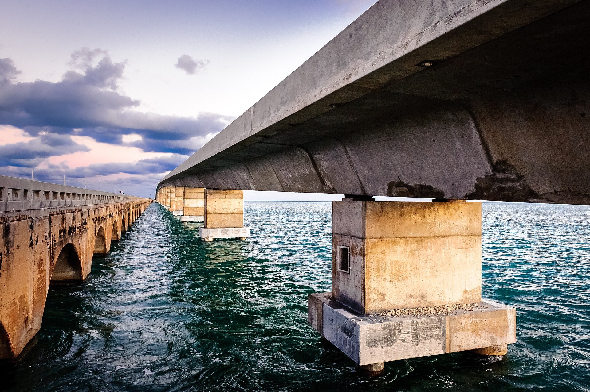
The modern Seven Mile Bridge, opened in 1982, is actually about 6.8 miles long and is the most photographed stretch of the Overseas Highway. Running beside it is the Old Seven Mile Bridge, built for Henry Flagler’s Overseas Railroad in the early 1900s and later converted for cars. A 2.2-mile section from Marathon to Pigeon Key reopened to pedestrians and cyclists in 2022 after a long restoration.
Park near the Marathon end and walk or bike out over open water. You will often see rays, sea turtles and sometimes dolphins in the channels below, and the light at sunset is outstanding. Pigeon Key itself is a 5-acre island that once housed railroad workers. Its historic buildings are managed by the Pigeon Key Foundation, which runs tours and transportation; check the foundation’s site for current access, hours and admission, since entry to the island is separate from the free bridge walk.
Good to know
There is almost no shade on the old bridge. In summer, walk it early or within two hours of sunset, and carry more water than you think you need.
Lower Keys: Bahia Honda to Big Pine (MM 37 to 29)
Once you cross the Seven Mile Bridge, the Florida Keys change character. The Lower Keys are flatter, quieter and wilder, with fewer resorts and more pine rockland and open water.
11. Bahia Honda State Park (MM 37)
Bahia Honda has the closest thing to a classic tropical beach in the Keys: pale sand, very clear water and enough depth to actually swim. The park has three main beach areas: Sandspur Beach on the Atlantic side, Calusa Beach near the old bridge and Loggerhead Beach. The remaining span of the old Bahia Honda Rail Bridge is the classic photo here.
The park’s concessionaire has run snorkel trips to Looe Key, a reef within the Florida Keys National Marine Sanctuary that many divers rate as the best in the Lower Keys. Check the Florida State Parks site for current trip availability, fees and any closures; the park also closes its gates to new arrivals when it hits capacity, so arrive early on holiday weekends.
For a day trip, Bahia Honda works best as your final stop before turning around. You can swim in the afternoon, then watch the light change over the old bridge as you head north.
12. National Key Deer Refuge and the Blue Hole (MM 30.5, Big Pine Key)
Big Pine Key is home to the Key deer, an endangered subspecies of white-tailed deer that stands about the height of a large dog. They live mainly on Big Pine and nearby No Name Key, and you will often see them grazing on road shoulders and in yards, especially early and late in the day.
Turn bayside onto Key Deer Boulevard and drive about 1.5 miles to the Blue Hole, a flooded former limestone quarry with an observation platform. It is the largest freshwater body in the Keys and attracts wading birds, turtles and the occasional alligator. Look for the refuge’s short trails nearby for more deer and pine rockland habitat.
Good to know
Speed limits drop sharply on Big Pine Key, especially at night, and are strictly enforced to protect the deer. Feeding Key deer is illegal under federal and state law.
Before heading back, the No Name Pub, a short drive off US-1 toward No Name Key, is a long-standing local spot for pizza with dollar bills stapled across the walls. It suits an early dinner before the long drive north.
Key West: only with a night
Key West is the end of US-1 and the image most people have of the Florida Keys, with the Southernmost Point buoy, Duval Street, the Ernest Hemingway Home and Museum, Fort Zachary Taylor Historic State Park and the nightly sunset celebration at Mallory Square. It is also roughly 160 road miles from downtown Miami. Driving down and back in one day leaves you about three hours in town, most of it spent looking for parking.
If Key West is your goal, book at least one night. Drive down at a relaxed pace using the stops above, catch sunset at Mallory Square, then explore in the morning before heading back. Key West is also the departure point for the ferry and seaplanes to Dry Tortugas National Park, about 70 miles further west. Getting to Dry Tortugas takes advance booking and an early start from Key West, so it adds at least one more night to your trip.
Reef, wildlife and water: what you are seeing
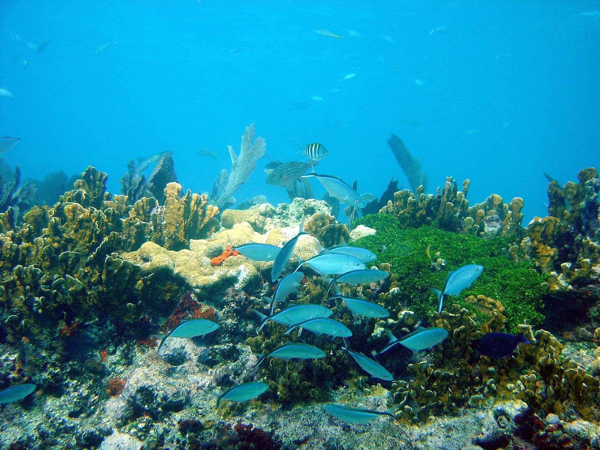
Florida’s Coral Reef is the only living barrier coral reef in the continental United States, running about 350 miles from the Dry Tortugas to St. Lucie Inlet in Martin County. The Keys section is protected inside the Florida Keys National Marine Sanctuary, which covers roughly 2,900 square nautical miles of water around the island chain.
The reef has been under heavy stress. Disease, heat and hurricanes have killed much of the coral, and the record marine heat wave of summer 2023 caused widespread bleaching across the Keys. You will still see healthy fish life, sea fans and patches of living coral, and restoration groups have planted large numbers of nursery-grown corals on Keys reefs. Go in expecting a real but recovering ecosystem rather than a postcard, and ask your snorkel operator which sites currently look best.
A few rules apply on and in the water:
- Do not touch, stand on or kick coral. Even a brief touch can damage living tissue, and sanctuary rules prohibit harming coral.
- Use mooring buoys, not anchors, if you rent a boat. Anchoring on coral is prohibited.
- Respect dive flags. Boaters must slow down and keep their distance from a displayed divers-down flag under Florida law.
- Keep your distance from wildlife. Manatees, sea turtles and dolphins are protected; do not chase, feed or touch them.
- Choose mineral sunscreen and cover up with a rash guard, which protects you and puts fewer chemicals in the water.
Above water, look for brown pelicans, ospreys, great white herons (found in South Florida and the Keys) and magnificent frigatebirds hanging motionless overhead. In the shallows off any bridge you can often spot spotted eagle rays, southern stingrays, barracuda and nurse sharks.
Florida Keys beaches compared
If your day is built around swimming, this table shows how the beaches on this route differ. “Water depth” describes typical conditions near shore on a calm day; tides and wind change it.
| Beach | Mile marker | Sand quality | Water near shore | Facilities | Best for |
|---|---|---|---|---|---|
| Cannon Beach, Pennekamp | 102.5 | Small, man-made | Shallow, calm | Full park facilities | Combining with a snorkel tour |
| Anne’s Beach | 73.5 | Narrow strip, patchy | Very shallow flats | Restrooms, boardwalk | Toddlers, wading, photos |
| Sombrero Beach | 50 | Good, wide for the Keys | Shallow to swimmable | Playground, shelters, restrooms | Families, picnics, free entry |
| Sandspur Beach, Bahia Honda | 37 | Best on the route | Clear, swimmable | Full park facilities | Real swimming, classic scenery |
| Calusa Beach, Bahia Honda | 37 | Small, sheltered | Calm, clear | Picnic area nearby | Snorkeling near the old bridge |
Seaweed and seagrass wash up on many Keys beaches, especially after storms. It is a natural part of the ecosystem and not a sign the water is dirty.
Best time to go
The Florida Keys are warm year-round, but conditions and crowds change a great deal by season. Use this table to match the trip to the calendar.
| Period | Typical conditions | Crowds | Watch for |
|---|---|---|---|
| December to April | Dry, breezy, highs mostly in the 70s and low 80s °F | Peak season, highest prices | Windy days that cancel snorkel boats |
| May | Hot, calm, water warming toward the 80s | Moderate | Weekend traffic, rising heat |
| June to November | Hot and humid, water in the upper 80s by late summer | Lower except July | Atlantic hurricane season (June 1 to November 30), afternoon storms |
| Lobster mini-season (last Wednesday and Thursday of July) | Hot, calm | Very heavy | Packed boat ramps and highway |
| Regular lobster season (August 6 to March 31) | Varies | Busy on weekends in August | Licensing and size rules from the Florida Fish and Wildlife Conservation Commission |
For a day trip, late April through May is the best window: calm water for snorkeling, long days, and fewer people than in winter. Winter has the most comfortable air temperatures, but strong winds can cancel boat trips. In summer, start very early, plan to be in the water by midday and watch for lightning when afternoon clouds build. Confirm current fishing and lobster regulations with FWC before you take anything out of the water.
Weekdays beat weekends in every season. Saturday mornings southbound and Sunday afternoons northbound are the worst times to be on US-1.
Where to eat along the way
Food in the Keys is mostly about fresh fish, conch fritters and key lime pie, served in casual, open-air places. A few reliable patterns help on a day trip:
- Breakfast: eat in Florida City or Homestead before you leave the mainland, or stop at Mrs. Mac’s Kitchen around MM 99.4 in Key Largo, a long-running local diner.
- Lunch: Islamorada has the widest choice of waterfront restaurants on the route, from the Hungry Tarpon at Robbie’s to larger bayside spots that face the sunset.
- Seafood market lunch: in Marathon, Keys Fisheries sits on the bayside off US-1 and serves fresh fish in a working marina setting.
- Early dinner: No Name Pub on Big Pine Key, or anywhere in Islamorada on the way back north.
Order fish that is local and in season, such as mahi-mahi, yellowtail snapper or hogfish when available. From mid-October, stone crab claws appear on menus during the state’s harvest season; confirm current season dates with FWC.
Getting home without the jam
The drive back north is usually harder than the drive south, because everyone leaves at the same time and US-1 narrows to one lane each way across much of the chain. A few habits make it easier:
- Leave Marathon by 5 p.m. on weekends, or wait until after dinner, to miss the peak northbound flow.
- Check traffic before Key Largo. If the 18-Mile Stretch is backed up, Card Sound Road is your alternative.
- Drive bridges in daylight where possible. The Seven Mile Bridge and Long Key Viaduct have no shoulders, and a breakdown stops traffic in both directions.
- Watch for sudden slowdowns. Crashes are common on US-1, and a single incident can close the road for hours.
- Refuel in Florida City if you are low, rather than paying Keys prices.
When to get help
For weather, tropical storm watches or evacuation orders, follow Monroe County Emergency Management and the National Weather Service Key West office. Call the specific park, hospital or attraction for same-day closures, and contact FWC with any questions about fishing, lobster or wildlife rules before you go.
Nearby: pair the Keys with these
If you have a second day, or just want something closer to home, several South Florida parks sit right on the way to the Florida Keys.
Homestead is the gateway to Everglades National Park; the main entrance near Florida City is only a few minutes off the Turnpike, so a morning on the Anhinga Trail pairs well with an afternoon in Key Largo. Biscayne National Park, with its Dante Fascell Visitor Center at Convoy Point in Homestead, protects coral reefs, keys and shipwrecks much closer to Miami, with boat trips run by the park’s concessionaire.
On days when the Keys are too far, you can still find clear water closer to home. South Beach beaches give you wide sand and lifeguards in the heart of Miami Beach, and Haulover Beach and Haulover Park in North Miami-Dade have wide sand, an inlet and a less crowded feel.
FAQ
How far is the Florida Keys from Miami?
Key Largo, the first island, is about 60 road miles from downtown Miami, roughly 1 hour 15 minutes with normal traffic. Islamorada is about 85 miles, Marathon about 115 miles and Key West about 160 miles, roughly 3 hours 45 minutes each way without stops.
Can you do Key West as a day trip from Miami?
You can, but it is a poor use of a day. The round trip takes 7.5 to 8 hours or more of driving, leaving you only a few hours in Key West. Book at least one night if Key West is your main goal, and use a day trip for Key Largo, Islamorada or Marathon.
What is the best island in the Florida Keys for a day trip?
Islamorada offers the best balance for most people driving from Miami-Dade or Broward. You can snorkel at Pennekamp in Key Largo in the morning, have lunch in Islamorada, feed the tarpon at Robbie’s and swim at Anne’s Beach, all within about 2 hours of home.
Are there good beaches in the Keys florida residents recommend?
Yes, but they are smaller than mainland beaches because the offshore reef blocks the waves that build sand. Bahia Honda State Park has the best natural beach on the route, Sombrero Beach in Marathon is the best free family beach, and Anne’s Beach in Islamorada is best for wading in shallow, clear water.
Do I need to book snorkel tours in advance?
On weekends, holidays and during winter and spring break, yes. Pennekamp boat tours, Turtle Hospital tours and Dolphin Research Center programs often sell out. Book online before leaving home, and choose a morning slot for calmer water and fewer cancellations.
What does MM mean in Florida Keys addresses?
MM stands for mile marker, the green roadside signs along US-1 that count down from about MM 126 near Florida City to MM 0 in Key West. Addresses also note oceanside (Atlantic) or bayside (Florida Bay), which tells you which side of the highway the place is on.
When should I avoid driving to the Florida Keys?
Avoid Saturday mornings southbound and Sunday afternoons northbound, holiday weekends, the two days of lobster mini-season in late July, and any time a tropical storm or hurricane is threatening. During hurricane season from June 1 to November 30, check Monroe County Emergency Management before you leave.